Development and optimization of an offshore hydrodynamic forecasting model
About 681 wordsAbout 2 min
2025-03-13
Introduction
The application of executable shoreline restoration units in shoreline restoration and the exploration of the impact of the scale and spatial arrangement of natural shoreline restoration projects on the peak water level (PWL), the concept of executable ecological restoration units, "Operational Landscape Units" (OLUs), was introduced and applied to the east coast of China, especially to the western part of the inland shelf of the Yellow Sea ( WYS), where the nearshore is divided into 18 county and district level areas. The effects of OLUs on the peak water level of the WYS were quantified through 24 sets of numerical simulation experiments. The effects of OLUs at different locations and scales were simulated by setting up different shoreline restoration scenarios and compared with a fully hardened shoreline. The study shows that rationally located OLUs can effectively reduce coastal flood risk and provide new ideas for coastal protection and restoration programs.

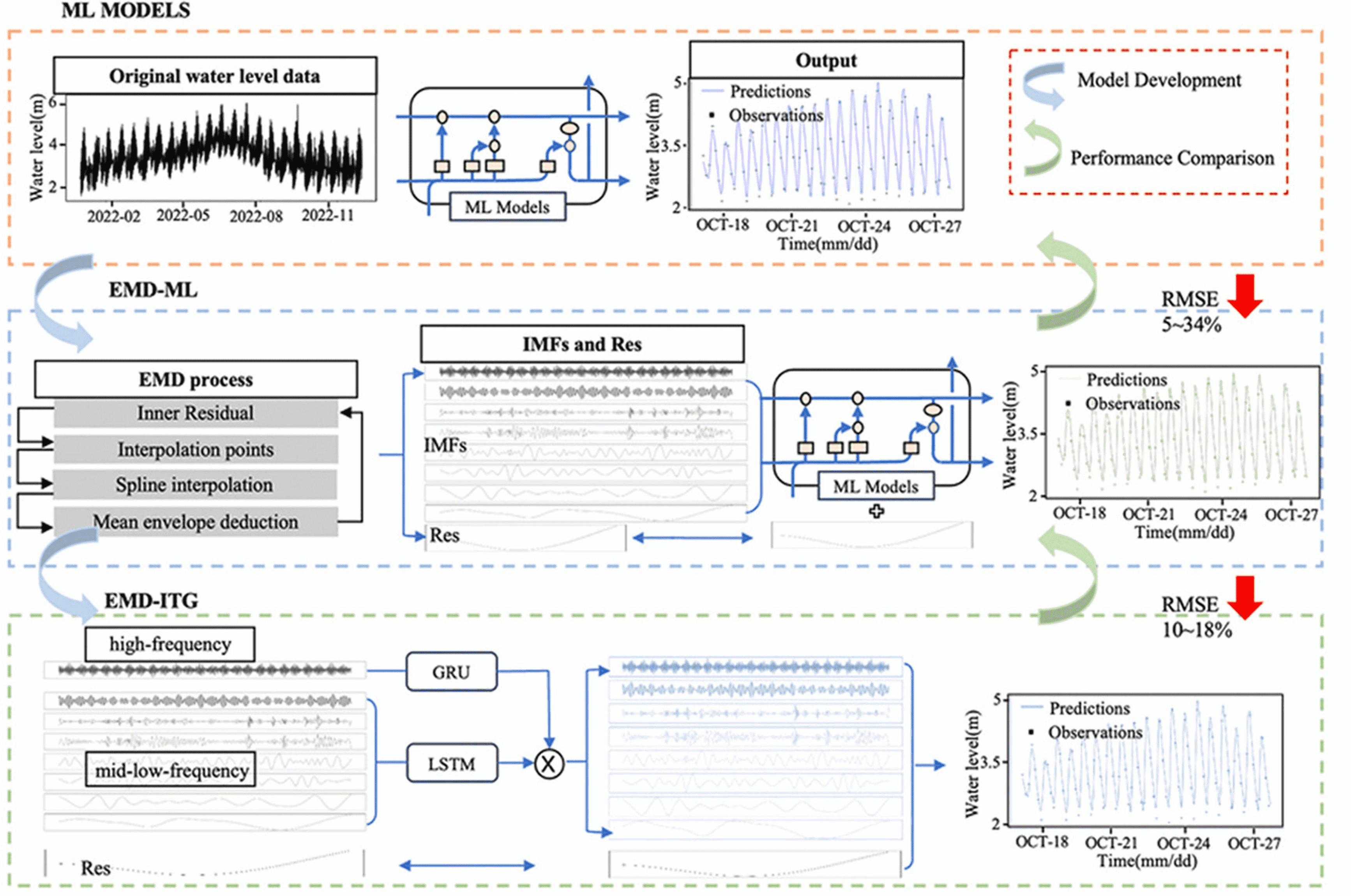
A hybrid prediction model of non-stationary water level in a tidally sensitive river segment based on deep learning and signal source processing
It is proposed by introducing an empirical mode decomposition (EMD) algorithm, which decomposes the non-linear and non-stationary water level time series into smoother intrinsic mode functions (IMFs) and brings them into a machine learning (ML) model. Intrinsic mode functions (IMFs) into machine learning (ML) models, a new hybrid short-term forecast model (EMD-ITG) is proposed. Taking the water level prediction from the tidal section of the Yangtze River to the open coast as the research object, based on the information of the measured tide station, the water level prediction is carried out by deep learning method to improve the accuracy of water level prediction.

Typhoon Path and Typhoon Wave Height Forecasting Based on the Pangu Meteorological Large Model
The Pangu Meteorological Large Model is a meteorological large model obtained by the Huawei Cloud team relying on powerful computational resources and massive data training, which greatly improves the forecasting accuracy and computational speed. The Pangu Meteorological Model is used to forecast surface meteorological elements and high-altitude meteorological elements under typhoon weather, and combined with the tropical cyclone tracking algorithm to forecast typhoon paths; the improved forecast wind field data-driven SWAN model based on the Pangu Meteorological Model's path prediction results and the direct correction method is applied to the typhoon paths and typhoon wave forecasts in Guangdong and Hainan Island. It is shown that the Pangu Meteorological Model (PAM) is capable of realizing long-time typhoon track forecasts, and the results are better than those of the high-resolution numerical atmospheric model (ECMWF-HRES). The combination of the typhoon track forecasted by the Pangu meteorological model and the direct correction method to improve the typhoon wind field as the wave field driver can effectively improve the forecast accuracy of the typhoon wave height, which is a reliable technical means for typhoon wave research and disaster prevention and mitigation in the coastal areas of China.

###Forecasting System for Offshore Hydrographic Information (FPOCH)
The Forecasting System for Offshore Hydrographic Information (FPOCH) aims to provide better services for underwater operations and submarine machinery platforms relying on offshore hydrographic information, and it is an automated forecasting platform for offshore hydrography and hydrodynamics that can be connected with underwater unmanned aircraft. In order to meet the requirements of offshore unmanned platforms for hydrological information transmission, LSTM algorithm and EMD-ITG deep learning method are adopted for data reanalysis and processing, which significantly improves the accuracy and timeliness of forecasts. The system collects 25 forecast points in the offshore of China, the southern coast of Jiangsu and other regions, and can provide multi-types of hydro-meteorological prediction forecasts such as waves, currents and winds.
